



Factsheet
Country/ies of origin United States
Operator(s) US Space Force
(Mission Delta 31)
(Mission Delta 31)
Type Military, civilian
Country/ies of origin United States
Operator(s) US Space Force
(Mission Delta 31)
(Mission Delta 31)
Type Military, civilian
Wikipedia
en.wikipedia.org › wiki › Global_Positioning_System
Global Positioning System - Wikipedia
1 day ago - The Global Positioning System (GPS) is a satellite-based hyperbolic navigation system owned by the United States Space Force and operated by Mission Delta 31. It is one of the global navigation satellite systems (GNSS) that provide geolocation and time information to a GPS receiver anywhere ...
Federal Aviation Administration
faa.gov › about › office_org › headquarters_offices › ato › service_units › techops › navservices › gnss › gps › howitworks
Satellite Navigation - GPS - How It Works | Federal Aviation Administration
August 17, 2026 - The basic GPS service provides users with approximately 7.0 meter accuracy, 95% of the time, anywhere on or near the surface of the earth. To accomplish this, each of the 31 satellites emits signals that enable receivers through a combination of signals from at least four satellites, to determine ...
Guiding the future of exploration. 🛰️ The GPS III satellites ...
13:09
How GPS(Global Positioning System) Works | Deriving GPS Equation ...
18:44
How GPS Works | How GPS Actually Knows Your Location | The Science ...
02:59
How Does GPS Work? | Britannica
02:24
How does GPS Works Satellites, Ground Stations, and Receivers - ...
How many GPS satellites are in orbit?
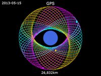
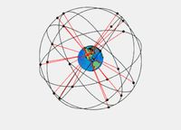
The GPS constellation currently has 32 operational satellites in medium Earth orbit at approximately 20,200 km altitude, distributed across 6 orbital planes with 55° inclination. The constellation requires a minimum of 24 operational satellites.
orbitalradar.com
orbitalradar.com › home › library › gps tracker
GPS Satellite Tracker — Live Map & Accuracy Heatmap
What is the difference between GPS and GNSS?
GPS is one specific satellite navigation system operated by the US. GNSS (Global Navigation Satellite System) is the umbrella term for all navigation satellite systems including GPS (US), Galileo (EU), GLONASS (Russia), and BeiDou (China).
orbitalradar.com
orbitalradar.com › home › library › gps tracker
GPS Satellite Tracker — Live Map & Accuracy Heatmap
How accurate is GPS?
Standard GPS provides approximately 3–5 metre accuracy for civilian users. Dual-frequency receivers using L1 and L5 signals can achieve better than 1 metre accuracy. Military M-Code provides sub-metre accuracy with anti-jam capabilities.
orbitalradar.com
orbitalradar.com › home › library › gps tracker
GPS Satellite Tracker — Live Map & Accuracy Heatmap
GPS
gps.gov › space-segment
Space Segment | GPS.gov
Expandable 24-Slot satellite constellation, as defined in the SPS Performance Standard. The satellites in the GPS constellation are arranged into six equally-spaced orbital planes surrounding the Earth. Each plane contains four "slots" occupied by baseline satellites.
Wikipedia
en.wikipedia.org › wiki › List_of_GPS_satellites
List of GPS satellites - Wikipedia
1 week ago - As of 2 September 2026, 83 Global Positioning System navigation satellites have been built: 32 are launched and operational, 7 are in reserve or testing, 41 are retired, and 2 were lost during launch. One non-operational prototype satellite was never launched.
Lockheed Martin
lockheedmartin.com › en-us › products › gps.html
Global Positioning System (GPS) Satellites | Lockheed Martin
Video: The GPS III series comes to a close with the final satellelite, GPS III SV10, which launched on April 21, 2026. Currently, there are 32 satellites on orbit in the operational GPS constellation, with Lockheed Martin building satellites ...
Orbital Radar
orbitalradar.com › home › library › gps tracker
GPS Satellite Tracker — Live Map & Accuracy Heatmap
September 13, 2026 - Track all 32 GPS satellites in real time. Live 6-plane constellation map, PDOP accuracy heatmap, GNSS comparison, signal frequency explorer, and L5 phone checker.
NASA Earthdata
earthdata.nasa.gov › home › find data › space geodesy techniques › gnss
Global Navigation Satellite System | NASA Earthdata
May 19, 2026 - The current GPS constellation includes 24 satellites, each traveling in a 12-hour, circular orbit 20,200 kilometers above Earth. The satellites are positioned so that 6 are observable nearly 100% of the time from any point on Earth.
Space Force
spaceforce.mil › about-us › fact-sheets › article › 2197765 › global-positioning-system
Global Positioning System > United States Space Force > Fact Sheets
The Global Positioning System (GPS) is a constellation of orbiting satellites that provides position, navigation, and timing data to military and civilian users globally. The system is operated and controlled by Space Delta 8, located at Schriever ...
NOAA National Ocean Service
oceanservice.noaa.gov › education › tutorial_geodesy › geo09_gps.html
The Global Positioning System: Global Positioning Tutorial
GPS is a constellation of satellites that orbit approximately 11,000 miles above the Earth and transmit radio wave signals to receivers across the planet. By determining the time that it takes for a GPS satellite signal to reach your receiver, ...
Plsc
plsc.net › what_is_gps.php
What is GPS?
August 17, 2026 - The 24 satellites that make up the GPS space segment are orbiting the earth about 12,000 miles above the earth. They are constantly moving, traveling at speeds of roughly 7,000 miles per hour, making two complete orbits in less than 24 hours. GPS satellites are powered by solar energy.
Federal Aviation Administration
faa.gov › about › office_org › headquarters_offices › ato › service_units › techops › navservices › gnss › gps
Satellite Navigation - Global Positioning System (GPS) | Federal Aviation Administration
Currently 31 GPS satellites orbit the Earth at an altitude of approximately 11,000 miles providing users with accurate information on position, velocity, and time anywhere in the world and in all weather conditions.
EarthScope Consortium
earthscope.org › home › what is geophysics? › gps
What is GPS? | EarthScope Consortium
July 8, 2026 - The Global Positioning System (GPS) was created by the US Department of Defense but ultimately made available for public use. There are other such satellite constellations, including Russia’s GLONASS and the European Union’s Galileo system.
NOAA Geodesy
geodesy.noaa.gov › INFO › facts › gps.shtml
What is GPS? | NGS Facts | NGS INFO - About Us | National Geodetic Survey
November 1, 2019 - Over 30 GPS navigation satellites are whizzing around the world, orbiting at an altitude of 12,000 miles, to help us find our way.
NovAtel
novatel.com › an-introduction-to-gnss › gnss-constellations › gps
GPS (Global Positioning System), United States | NovAtel
GPS (or NAVSTAR, as it is officially called) satellites were first launched in the late 1970s and early 1980s for the U.S. Department of Defense. Since that time, several generations (referred to as “Blocks”) of GPS satellites have been launched.
NASA
nasa.gov › directorates › somd › space-communications-navigation-program › gps
GPS - NASA
September 25, 2023 - Today the GPS satellite constellation (the space segment) consists of over 30 operational satellites, each equipped with redundant atomic clocks and tracked by a ground control network (the control segment).
Navigation Center
navcen.uscg.gov › global-positioning-system-overview
Global Positioning System (GPS) Overview | Navigation Center
The GPS concept of operation is based upon satellite ranging. Users figure their position on the earth by measuring their distance from the group of satellites in space. The satellites act as precise reference points. Each GPS satellite transmits an accurate position and time signal.
Navigation Center
navcen.uscg.gov › gps-constellation
GPS Constellation | Navigation Center - uscg navcen
August 7, 2026 - A depiction of the GPS constellation of satellites with slot and plane designations is provided here as an easy-to-read graphic which will be updated as satellites enter or leave the constellation. During the GPS modernization process, the orbital configuration, as indicated by the constellation slant chart, and control station configuration may not match over the long term.
Satellite Map
satellitemap.space › constellation › gps
Find GPS Satellites — Track 80 Live in 3D
There are currently 80 active GPS satellites in orbit out of a planned constellation of 32. Operated by US Space Force.
Wikipedia
en.wikipedia.org › wiki › GPS_satellite_blocks
GPS satellite blocks - Wikipedia
May 26, 2026 - GPS satellite blocks are the various production generations of the Global Positioning System (GPS) used for satellite navigation. The first satellite in the system, Navstar 1, was launched by the United States Air Force on 22 February 1978. The GPS satellite constellation is now operated by ...
Space.com
space.com › technology
GPS: Everything you need to know about the space-based technology keeping us on track
December 6, 2022 - Originally called Navstar GPS, this space-based technology is owned by the U.S. government and operated by the U.S. Space Force and relies on a swarm of 31 satellites to provide users with approximately 23 ft (7 meters) accuracy, 95% of the ...